
Editor’s Note:
This article on the Blue Ridge Parkway, highlighting its beautiful scenic drives, was written prior to Hurricane Helene’s impact on the region. Our thoughts and hearts go out to all those affected by the storm. We hope for a swift recovery for the communities impacted and encourage everyone to support local relief efforts.
A Northerner’s Guide to Road-tripping on the Blue Ridge Parkway
As famous as it is, the Blue Ridge Parkway — that iconic drive through the mountains from the western part of Virginia to the southwest corner of North Carolina — occupies its own space and time.
It was built as a Depression-era project to preserve both the glorious views and harder-to-see species that have forever made the adjacent national and state parks their homes.
The 469-mile parkway is free of billboards, which is lovely, but that also means that it is devoid of the familiar symbols of highway progress. Granite posts mark the miles and are the main reference point for navigation, which can make it hard to figure out exactly where to get on or off.
All of this means that you must give in to the rhythm of the parkway rather than relying on a map app or road signs. It’s worth it.
In its entirety, the parkway is about a four-day stretch of spotty satellite downloads, two-bars-max cell service and views of eternal blue skies dramatically unveiled and then veiled again by sweeps of mist. The turning foliage in fall brushes the steep channels of the gaps with gold.
On the parkway, you drive the spine of the mountain the way an Olympic gymnast works the balance beam. And yes, your hand had better be that confident on the wheel, because much of the steep and winding road lacks guardrails. Skipping from one scenic turnout to the next, you’ll zigzag from viewpoints looking west, to east, to west, to east, across hollows and gorges to the soft valleys far below. But then, just a few miles later, the parkway enters mountain meadows and the land unfurls on either side of the road, the occasional farm spreading its apron right to the shoulder with cows watching on.
It carries on like this through southwestern Virginia and continues over the state line to end southwest of Asheville, North Carolina. 
It’s a glorious drive.
It’s also a state of mind as much as it is a place on the map, which explains the many logistical disconnects between the parkway and the outside world. From I-81, the small signs that point to the occasional side entrance to the parkway come up suddenly, with no warning, and then are gone. You might be able to react in time for a quick turn onto the parkway. But probably not.
So the best way to experience it is on purpose, starting at the top — at Rockfish Gap, Virginia. At 45 miles an hour and no passing, thank you very much, it’ll take a couple of days to make the border of North Carolina, and give you plenty of time to pull over and take in the views, visitors’ centers and an occasional historic cabin. Then, you can exit gracefully on Route 52 back to the world of passing lanes and fast-food joints, and speed your way to the coast or down to Florida.
For a bit of a longer trip, continue on the parkway through North Carolina, where the drop-offs are even steeper and where you can visit art centers and historic sites, and eventually, detour to Asheville, with its food scene and terrific regional museums.
Here’s how to incorporate the Virginia section of the parkway into a road trip to points south.
First, decide whether you’ll stay overnight, which you should, at the only official National Park lodge on the parkway in Virginia: Peaks of Otter Lodge (Milepost 86). If you don’t want to stay overnight, which requires reservations, you’ll have to figure out where you will exit the parkway before dark and find accommodation in the outside world.
The Peaks of Otter Lodge is a Brady Bunch-era motel with three great virtues: Every room has a small private balcony overlooking a sparkling lake; the dining room serves an excellent shrimp and grits with a smoky tomato sauce that is not too spicy — i.e., acceptable to Northern palates; and several short hiking trails and a visitor center are nearby, which means you can justify the 1,000 calories in that bowl of shrimp and grits.
But before you can get to the lodge, you’ll need to figure out how you’ll get to the parkway. From wherever you are starting, use your fully responsive GPS to find the “Skyline Drive Rockfish Gap Entrance Station.” Note that Skyline Drive/Route 340 is not the Blue Ridge Parkway: Rockfish Gap is where the Skyline ends and the parkway begins.
That’s right: Use the coordinates for another road to find the entrance to the parkway. I know, I know. But it’s going to keep on just as it starts. Once you’re on the parkway, it’s hard to know where provisions or gas might be found in the (invisible) outside world. So arm yourself with a printed map. A paper map. As soon as you cross into Virginia, stop at the nearest visitor center and pick up the most detailed map of the Blue Ridge Parkway you can find. The official National Park Service map is fine. The $15 National Geographic map is better (and can be bought online in advance).
Now, you can enter the alternate universe of the parkway without a care. Your devices won’t be able to find reliable connections, but that’s OK: You have a map.
From Rockfish Gap, start driving south, which also means driving up. Whatever the weather was in the valley is not going to be the weather on the way up. Mist will drift. The sky will flash blue, then disappear in a bank of fog. It’s OK. You have a map. And with every passing granite mile marker, you have solid confirmation that you’re going in the right direction — the only direction, actually.
Keep driving for about four hours, give or take stops to take in the view and visit the occasional visitor center and then arrive at the Peaks of Otter Lodge, with its warm, glowing windows and the promise of a hot dinner. Stay for the night, or two, if you want to hike further up the mountain.
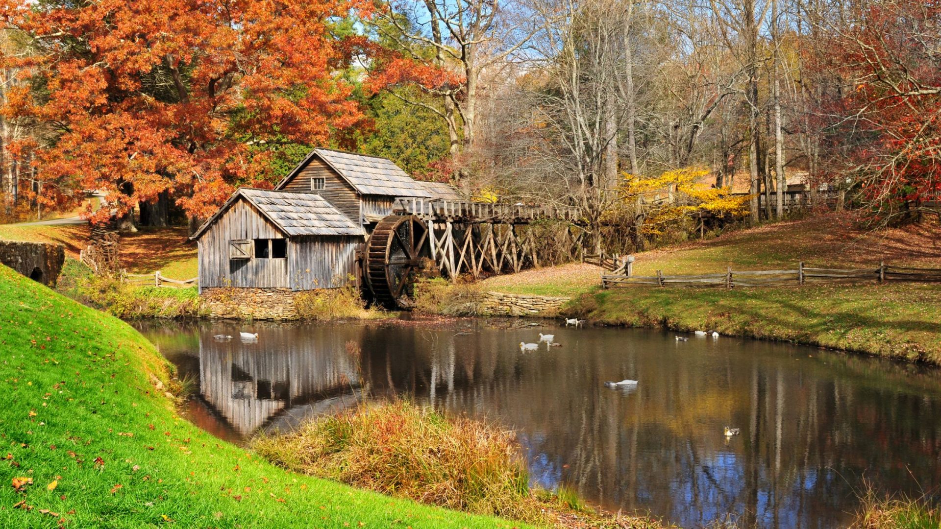
When your itinerary (and the rest of your prepaid hotel reservations) tell you it’s time to go, go. At 45 miles per hour, go carefully. It will take most of the second driving day to complete the Virginia portion of the parkway. Plan to stop at Mabry Mill, a 120-year-old gristmill. If the restaurant and gift shop at the mill is closed, as it will be for part of 2024, take the next exit off the parkway to the Meadows of Dan. Barely a quarter mile back into the real world, you can fuel your car at a gas station and yourself at Jane’s Country Café. Order the chicken salad.
Just before exiting the parkway for good at Route 52, which will take you back to the fast lane, stop at the Puckett Cabin. It’s a gray, weathered shack just like the ones that the German, Scottish and Welsh settlers built two centuries ago, when the parkway was just a path and the views were the backdrop to daily chores.
Time spent on the parkway won’t make you a Southerner, not any more than having some chowder makes a Blue Ridge native a Yankee. But it’s a lovely way to see what their grandparents wanted to save, for them, and for us all: a view of the earth from halfway to heaven.
Tips for Your Drive
• Check the National Park Service weather and condition reports for the parkway. Conditions change quickly, especially in spring and fall. The parkway is closed in the winter.
• Be sure your brakes work.
• Monitor your gas consumption carefully, as there are no gas stations on the parkway, nor are there signs to gas stations.
• Ditto coffee consumption, as the visitor centers pop up only every 50 miles or so.
• To stay at the Peaks of Otter Lodge, make reservations well in advance at peaksofotter.com. It’s best to book directly with the lodge to avoid confusion that arises when booking through third-party sites. The lodge offers updated rooms and strong Wi-Fi, which is nothing to take for granted given the almost nonexistent cell service on the parkway.
Top photo: Mabry Mill on the Blue Ridge Parkway (iStockphoto.com/LaserLens)